Where are Ron and Ellen?
Portugal (Ron and Ellen), Southeastern Africa (Ron), 19 September 2013 - 13 January 2014
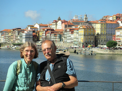
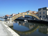
Ron and Ellen in Porto, Portugal, October 2013
Porto, Guimaraes, and Aveiro, Portugal
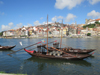
To see photos of Porto, click on the thumbnail at the left.
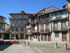
To see photos of Guimaraes, click on the thumbnail at the left.
Porto and then south
To see photos of Aveiro, click on the thumbnail at the left.
9 October 2013
Sagres, PortugalDear Family and Friends,
We are heading south from Porto on the toll road towards Lagos on the southern coast, taking advantage of driving time to begin writing this message (most of which was written a day later in Sagres). The roads, both the toll roads and the smaller roads, are all well-maintained, and all amazingly free of any litter. Cars are almost all smaller here than in the US - and people drive much, much faster. Speed limit on the toll road is nominally 120 km/hr (72 mph), and when we are driving at that rate or up to 130 (78 mph) almost everyone zooms past us at a significantly greater speed.
Our trip from Evora to Porto was an easy one - until the end! We had map of Porto, the second largest city in Portugal, knew the street we were going to for the apartment we'd rented, and had plotted a route we thought would work. That was foiled when the road along the river that would have taken us to the center was closed for some reason. The policeman turning people back told us to go back to the two traffic circles and at the second one follow the signs to "Centro." Easier said than done. We did ok for a bit following the signs, but had no clue where we were on the map. We stopped several times to ask for directions (a major task to find a place where we could pull over for a few moments so one of us could get out with the map), but the people we asked obviously didn't drive because they gave directions that couldn't be followed because of one way streets. Being an old city and built on a hill, nothing is straight of course. We did one loop several times! We finally called the apartment manager, who called her housekeeper, and we kept describing to her where we were until we were finally at a place that she said was nearby. She told us to pull over next to the park (luckily we could do that) and she would come meet us. She found us when Ron stood by the car and waved. It was a good thing she found us and directed us because we would never have recognized the place to turn for the street the apartment was on - it looked like a broad swath of pavement where people parked, but when you went between the parked cars and around a bend, there was the very narrow, very steep one way street! We parked the car on the street and didn't move it again until time to leave! Planning for our departure from Porto today, we plotted what looked like an easy route to the highway along the river that would take us to the toll road south, walked the route (it wasn't very far) and hoped whatever had blocked the route last Thursday would no longer be blocking it. And indeed, we left Porto in less than 15 minutes apartment to toll road, as opposed to the hour plus it took us from toll road to apartment. As we crossed the big bridge over the river, Ron said it was the last of our difficult driving until we return the car in Lisbon - and then added "Famous last words!"
We thought Lisbon was hilly, but parts of Porto are even more vertical, climbing up the steep hills from the river on both sides. One afternoon we had tea at a little cafe on the street just above the river, and the sidewalk and therefore the table were at such an angle that we had trouble keeping the teapot and cups from sliding off the table until we propped the top of one of the chairs under the downhill edge of the table. Our studio apartment was in a recently renovated building near the top of one of the hills, so we did a lot of up and down walking to get to and from the riverfront, let alone exploring the various parts of the old city. Lots of traffic, but also a fair number of walking streets - or streets that are so narrow that they have very little traffic in them. From the various hilltops there are spectacular views over the rooftops below and over the river. The area aound Porto is where Port wine comes, and the various port wine houses line the riverside across from the city with (replicas, we are sure) of the old boats that used to bring the barrels of wine downriver to the city now giving river cruises to tourists. We had four days there, and spent two exploring the city, going in and out of various incredibly ornate churches and the surprisingly plain cathedral, and visiting the building that was the birthplace of King Henry the Navigator in 1304, later the customs house for Porto. Recent renovations have uncovered ruins of a Roman building and a Roman mosaic under the 14th century structure, and glass flooring allow you to see the Roman parts as you walk around. Then we took two different day trips using the excellent suburban trains (definitaly not moving the car!) one to Guimaraes and one to Aviero.
Guimaraes is a small town to the northeast of Porto that was the very first capitol of Portugal, home of the the man born in 1110 who became the first independent king. Its center is a lovely warren of medieval streets, now lined with shops and restaurants, but with apartments above. It is a UNESCO World Heritage site and deservedly so. It was a Saturday when we were there, and the streets were very lively, with a number of street performers playing music or doing various acts. We toured the castle, originally built in 1401, then falling into ruin, and restored in the 20th century. It is all stone, with big rooms that must have been dreadfully cold in the winter, despite tapestries lining the walls and huge fireplaces.
Aviero, south of Porto on the coast (or, more accurately, at the mouth of a river that has created a huge area of tidal marshes, is called "the Venice of Portugal," but looks more like Holland, with lots of canals through the town. It was traditionally a fishing and salt-producing area, and they still produce salt there - not sure about the fishing. Most of the small houses in the old part of the town have tile facades, the widest variety of tiles we've seen anywhere, traditional styles and modern designs and a huge assortments of colors. And Aviero was flat - what a treat to explore a town without climbing hills!
When we got to the Algarve, the southern coast of Portugal, after a drive from Porto of about 5.5 hours, we looked unsuccessfully for apartments with sea view (in our price range) in two tiny towns before ending up in Sagres, which is the most southwestern town in Europe. Cape St. Vincent is a rocky point jutting out into the Atlantic, and, as one of our guide books says, it is the last land the apprehensive Portuguese sailors would have seen as they headed off on their various voyages of discovery and commerce.
We are in an "aparthotel," something between an apartment building and a hotel, with living room, bedroom, kitchen, bath, and balcony overlooking the water. For the first night we were in a room with a spectacular west view over the Atlantic, the cape and the fortress on the end of it, but had to move to another room for the rest of our stay. We have the same layout (mirror image), looking over the Atlantic on the south coast and the cliffs going east into the distance. We anticipate a few lazy days sitting on our balcony, plus some walking along to the cape and around the area, since we are in the southernmost part of a natural reserve area that stretches for a huge distance north along the coast.
Love to all,
Ellen and Ron
Back to the Fall 2013 index
cfw.com
Questions? Send email to Ellen, ebouton 
Last updated: 31 October 2013